

The meeting of the consultative committee of the Ministry of Civil Aviation was held on Thursday, December 08. Union Civil Aviation Minister Jyotiraditya M. Scindia presided over the meeting.
The subject of discussion was GAGAN (GPS Aided Geo Augmented Navigation) system which is a Space Based Augmentation System (SBAS), developed jointly by Airports Authority of India (AAI) and ISRO.
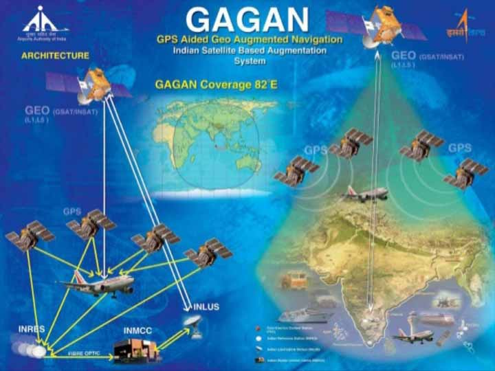
What is GAGAN ?
GAGAN is an acronym for GPS Aided GEO Augmented Navigation. It is a Space Based Augmentation System (SBAS) jointly developed by ISRO and AAI to provide the best possible navigational services over Indian FIR (Flight Information Region) with the capability of expanding to neighbouring FIRs.
GAGAN is a system of satellites and ground stations that provide GPS signal corrections, giving you better position accuracy. GPS alone does not meet the ICAOs navigational requirements for accuracy, integrity and availability. GAGAN corrects for GPS signal errors caused by Ionospheric disturbances, timing and satellite orbit errors and also it provides vital information regarding the health of each satellite.
GAGAN is also part of Global Navigation Satellite System (GNSS), which takes the input from the core GPS (Global Positioning System) constellation and augments navigation data through the GEOstationary satellites for providing better accuracy, integrity and continuity of service for its application in civil aviation. National Civil Aviation Policy (NCAP-2016) prescribes that new aircraft being registered in India from 1stJanuary 2019 will mandatorily have to be GAGAN enabled. DGCA issued a public notice stating that “all aircraft registered in India from 1st January 2019 will be required to be GAGAN enabled.” (This date was later revised to 1st July 2021.)
How it works ?
GAGAN consists of a set of ground reference stations positioned across various locations in India called the Indian Reference Station (INRES), which gathers GPS satellite data. A master station, Indian Master Control Centre (INMCC) collects data from reference stations and creates GPS correction messages. The corrected differential messages are uplinked via Indian Uplink Station (INLUS) and then broadcast on a signal from three geostationary satellites (GSAT-8, GSAT-10 and GSAT-15). The information on this signal is compatible with basic GPS signal structure, which means any SBAS-enabled GPS receiver can read this signal.
Coverage area
Two GEOs simultaneously transmit the GAGAN signal in space. GAGAN GEO footprint expands from Africa to Australia and GAGAN system has capability to cater 45 reference stations for expansion to neighbouring countries.
GAGAN provides a civil aeronautical navigation signal consistent with International Civil Aviation Organization (ICAO) Standards and Recommended Practices (SARPs) as established by the Global Navigation Satellite System (GNSS) Panel. The GAGAN system provides Non-precision approach (NPA) service accurate to within the radius of 1/10th of a nautical mile (Required Navigation Performance or RNP-0.1) over the Indian FIR as well as precision approach service of APV-1.0 (Approach with Vertical guidance) over the Indian landmass on nominal days.
The system is interoperable with other international SBAS systems such as the U.S. Wide Area Augmentation System (WAAS), the European Geostationary Navigation Overlay Service (EGNOS), and the Japanese MTSAT Satellite Augmentation System (MSAS), and provides seamless air navigation across regional boundaries.
Benefits of GAGAN
GAGAN has benefits in aviation as well as in non-aviation fields.
In the aviation sector, on the safety front, GAGAN is operational and offers two levels of service-RNP 0.1 (Required Navigation Performance 0.1) over Indian Flight Information region and APV I (Approach with Vertical Guidance, Level I) over major part of Indian landmass, to its aviation users. GAGAN can support operations for all phases of flight including Oceanic, Approach, Terminal, Surface. GAGAN system provides lower operational minima on non-ILS runways and supports advanced procedures like curved approaches. GAGAN helps in designing more efficient routes which can result in fuel savings. It can help in operations in areas with absence of navigation infrastructure. GAGAN can work as backup to ILS approaches.
In Non-Aviation, GAGAN helps in Disaster Management. With the use of GAGAN message service (GMS), early warning messages can be broadcast on the occurrence of natural disasters, calamities, dangers for the safety of life within the GAGAN coverage area for search and rescue messages, relief and mitigation-related messages, meteorological information and other uses.
GAGAN can enhance safety, mobility, regulation and enable payment applications. In the road sector, it can offer smart mobility for lane guidance, better traffic management, speed control and traffic violation, Real time tracking of public transportation assets. With the use of GAGAN, initiation of alarm and barrier closure can be automated, monitoring of train movements and automated train stopping can be achieved to reduce the risk of accidents.
GAGAN can improve Navigation and Positioning in the Indian Subcontinent and Inland waterways by tracking proximity of ships, enabling safe docking of ships at ports, enhancing coastal security and tracking of ships.
Current Status
The Airport Authority of India designs various types of landing approach procedures for various Indian Airports. Till date, 51 GAGAN based approach procedures have been designed for various runways of Indian airports. Flight trials using GAGAN based LPV approach procedures were successfully conducted by Indigo on 28th April 2022 at Kishangarh Airport, Rajasthan.
As on date, 02 GAGAN based approaches for two runway ends of Kishangarh Airport have been promulgated in Aeronautical Information Publication (AIP) for aviation usage. Conduct of flight trial using GAGAN based approaches is planned to be conducted shortly for Kannur Runway (RWY) 07. Flight trials of GAGAN based approaches for Mumbai RWY 32 and Cochin RWY 09 are planned to be conducted after approvals from DGCA.
AAI is making all the efforts for ensuring availability, continuity and integrity of Air Navigation services by such technological enhancement in India.


Related Items
Rural Development Ministry launches real-time audit portal to replace manual tracking
SC has recognised Ministry’s Green Aravalli Project; rumours unfounded: Bhupender Yadav
IndiGo crisis: Civil Aviation Minister says minimising inconvenience for passengers